Blueways and Greenways with funding from the EU through various Government Departments, County Councils and Waterways Ireland, are being developed along the Grand Canal, Royal Canal and the Barrow Line.
Blueways
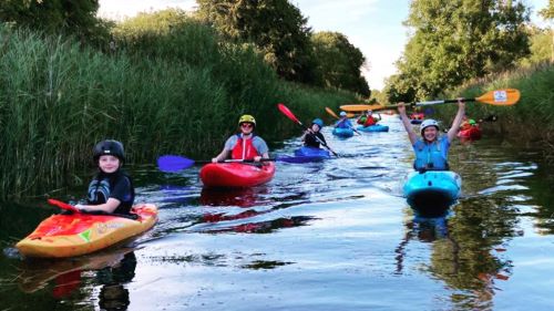
Located along Ireland’s canals, coastlines, lakes and rivers, have been developed as a network of approved and branded multi-activity recreational trails and sites for children and adults, based on and closely linked with the water.
Blueways in Ireland represent
- Being active in nature
- Exploration of waterscapes
- Service providers enabling easy access for all
- Multi-activity trail options
- Set within the context of places to stay, eat and go
- Enriched by local culture, heritage, arts and visitor attractions
- Responsible recreation within the environment
The Barrow Blueway is 63 km in total with 47 km in Kildare and 16 km In Laois. It starts in Robertstown/Lowtown and ends in Athy and is scheduled for completion in 2025.
The following reports are available on the Kildare LEADER site. They show plans and progress for the Barrow Blueway to February 2023.
Barrow Blueway Economic Plan 2021/2022
The purpose of the economic plan is to inform, guide and encourage economic development initiatives that will bring the experience of the Blueway to life for all users – local people and visitors.
Doing Business on the Barrow Blueway 2021
This guide was prepared to inform businesses and raise awareness about what you need to do, and to connect you to the right organisation.
Barrow Blueway Placemaking Plan 2023
The purpose of this plan is to set out a ‘shopping list’ of programmed and costed actions to meet the Blueway accreditation criteria. The target audience is decision makers such as KCC, LEADER and WI as well as local community groups and private enterprises.
Local Just Transition Plan for West Kildare
This Just Transition Plan has been commissioned by Kildare County Council to identify projects to support and advance sustainable social, economic and environmental development in the transition to a low carbon future in the West Kildare region.
Some of the key actions included in the plan are:
- Progress the opportunity for a new National Peatlands Park for Ireland
- Stimulus for community owned marinas and facilities as key Blueway infrastructure to support the growing tourism sector
- Encourage new community development groups to emerge
- Grow the capacity for communities to help themselves through ‘One-stop shops’ at community hubs. These will enhance the ability of communities to access funding opportunities and skills training, as well as supporting remote working
- Community retrofit support
A description of the work to be carried out.
Greenways
They are predominantly traffic-free, flat surfaces, wide enough to accommodate shared usage by pedestrians, cyclists and other non-motorised users, such as wheelchairs, buggies, etc.
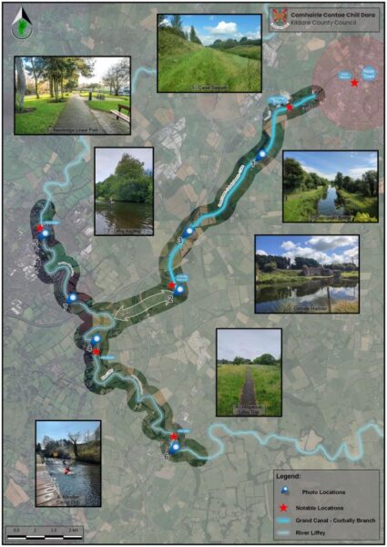
Greenways have been created in Kildare along the Grand Canal and the Royal Canal. The official opening of Phase 1 of the Grand Greenway in Kildare and the new Pedestrian Bridge, took place in Sallins in January 2024. The next step is the Part 8s Planning consultation for a linked piece in Sallins and Phase 2 from Sallins to the Offaly border. The Royal Canal Greenway was opened in 2021. Work is also in progress on a path to the Pollardstown Fen along the Milltown Feeder. The extension of the Grand Greenway from Sallins to Naas and Corbally Harbour joining up with a multi-use path to Athgarvan, Kilcullen and Newbridge will be a welcome extension and will give Kildare an outstanding outdoor amenity for locals and visitors. Exploring the banks of Ireland’s Historic Canals
Boaters among us walk or cycle along the towpaths between locks; an event for Kildare members is meeting up along some stretch of Irish waterway, for the Annual Winter Walk in December. See our Calendar for next December’s event and check here for other walks along waterways. No bikes on board, contact Barrow Way Bike Hire located on the Barrow Blueway in Vicarstown or Grand Canal Bike Hire located at the Canal Stores in Sallins.
Towpath Trails is an excellent guide to the paths along the Grand and the Royal Canals in Kildare. Created by Eamon Sinnott with input from Liam Kenny and others, for the Kildare Sports Partnership.
Maps of the Irish canals can be purchased in a handy spiral bound guide at the IWAI Shop. Charts of the waterways available on a tablet or smartphone are available to IWAI members at IWAI CSIG. As well as Charts, the IWAI Shop has books on all aspects of the Irish canals, lakes and rivers.
Update Feb 2022: The Royal Canal Greenway is proving to be very popular and is bringing income to rural communities along its length.
It is a “joint initiative between Waterways Ireland and the Local Authorities. It is the longest Greenway in Ireland, running from Maynooth, Co Kildare to Cloondra, Co Longford.
Tracsis Traffic Data Ltd were appointed by Waterways Ireland during 2021 to firstly validate counts from existing visitor monitoring devices along the route, and then to use a moderated count as the basis for calculating the economic impact of the Greenway.
- The validation research cross referenced visitor data collected by physical counters, to data collected through visual monitoring by field researchers. This indicated 640,000 visitors during the year-long study period.
- Quantitative data relating to recreational behaviour and consumer spending along the Royal Canal Greenway, was also derived from a robust sample of more than 700 respondents using an online survey.
The research found that the amenity has returned a dividend of €17.2m (versus a cost of €12.0m) to the business community in its first year of operation, returning the initial investment in the project in just over eight months. The economic dividend was based on a weighted average visitor spend of €27.” Source Waterways Ireland RCG Survey Infographics.
We look forward to the completion of the Grand Greenway in the near future. Walking on the Corbally Grand & Naas by Royal Canal Runner.

KCC’s vision of Greenway from Naas to Corbally, Athgarvan, Kilcullen and Newbridge


