Observations have to be submitted by Oct 28 2021 The Planning Application Number is 3513/21.
Go here to register with Dublin City Council and make a submission:
https://planning.agileapplications.ie/dublincity/application-details/146158
Once you are registered, you will be able to see the reports showing DCC’s proposal and drawings here
https://webapps.dublincity.ie/AniteIM.WebSearch/Results.aspx
This Drawing shows the proposed width of the navigation for the four areas. Extracted below as Sections 1, 2, 3 and 4.
https://webapps.dublincity.ie/AnitePublicDocs/00967123.pdf
………………………………………………………………………………………………
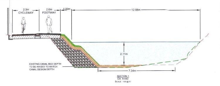
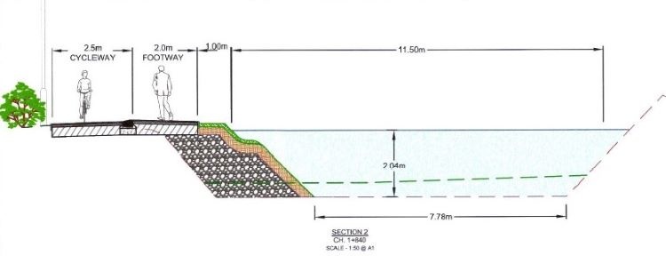
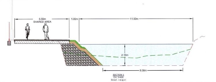
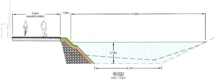
Dublin City Council have lodged changes to the original planning application for the Royal Canal. An Amending Part VIII Report proposes to expand into the width of the navigation in four locations.
While the dimensions look sufficient on the surface, they have not allowed for the shape of the canal and what takes place with barges and boats 1.5 metres under the surface. These proposals reduce the full navigation capacity.
These drawings of Sections 1, 2, 3 and 4, taken from the Amending Part VIII Report, show there is not sufficient space for two boats to pass and repass at the same time’ https://www.irishstatutebook.ie/eli/1988/si/247/made/en/print.
………………………………………………………………………………………………..
The Irish Times of Sep 21 2021 describes the situation as:
Dublin City Council is seeking planning permission to narrow the Royal Canal at three stretches (Ed. four locations) between Cross Guns Bridge and Ashtown village in Dublin’s north inner city.
The council wants to facilitate the Royal Canal Greenway, to assist access for residents’ vehicles and improve access for maintenance vehicles .
The area includes some of the oldest stretches of the canal with construction work having commenced in May 1790 at Cross Guns Bridge, heading west via Ashtown, ultimately to the Shannon just west of Longford town. A plaque beneath the keystone of Ranelagh Bridge at Castleknock commemorates the start of the work. In 2015, the city council began extending a walking and cycling route along the Royal Canal from Ashtown to Sheriff Street Upper.
The new application is to “widen the existing towpath” which is to be “achieved by narrowing the canal channel along three sections of the route”. The three sections are: west of Lock 6 over a distance of 600m; west of Broombridge over 345m and west of Lock 8 over 85m.
Ecological corridor
The council said the aim was “to provide a premium quality cycle and pedestrian route to facilitate and encourage cycling and walking” while maintaining the canal as an ecological corridor and improving vehicular access for residents and maintenance vehicles.
The development is to be undertaken by the council using part 8 of the Planning and Development Act which allows no appeal process to An Bord Pleanála.
The canal is a natural heritage area and the council’s development plan 2016 – 2022 designates it as a conservation area.
Waterways Ireland, which manages the canal, said what it described as “widening into the canal” – meaning that the path would be widened and the waterway narrowed – has taken place at other locations across the canal network to facilitate the construction of cycle paths. It added that it “supports both navigation and cycle amenity uses of the canal corridor”.
