The Corbally Canal, also known as the Herbertstown Branch of the Grand Canal, extends from Naas Harbour to Corbally Harbour in the countryside north and east of Kilcullen, Athgarvan and Newbridge. It is the Feeder for the Naas Canal. Water is fed from the Rathmore Spring into Corbally Harbour, a KCC Protected Structure, then through a large pipe under the Newbridge Road (R445), past Naas Harbour and the locks on the Naas Canal, to the Main Line of the Grand Canal at Soldier’s Island, west of Sallins. Unfortunately, the R445 in its current form, makes it impassable for walkers, cyclists and boaters.
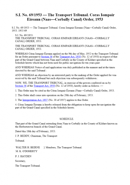
 The Transport Tribunal in Feb 1953, released CIE of its obligation to keep the Corbally Canal open. The road authority in 1954 when building what was then the main road to Limerick, was allowed build the road across the canal effectively creating a barricade with a culvert underneath. This prevented people and boats making their way along the canal past this point, but did allow the water to get through.
Today, it seems amazing that this was permitted, but it was at a time when canals transported goods and the potential for leisure activities and tourism on rural Canals was not envisioned. The IWAI, a volunteer group founded in 1954, focused all their energy in the initial years, on ensuring the proposed new bridges on the Shannon would not block the navigation. It was not until the 1960s that the idea of canals as a recreational facility came into vogue and by then it was too late for the Corbally Canal. Until recent years, there did not seem much hope of changing this disastrous decision. However, now with the M7, M9, M8, and the recent Sallins Bypass, the road blocking the canal is now designated as (R)egional. Today, the IWAI, Kildare County Council and local organisations, are actively campaigning for the reopening of this canal to Corbally Harbour, as a safe amenity for people of all ages, both locals and tourists.
Waterways Ireland continue to maintain the canal by removing weed and silt every year, to allow the water to flow and to ensure it does not overflow onto adjoining lands.
In recent years, with the emphasis on health, safety and outdoor recreation, there has been considerable interest expressed in creating an off-road facility for everyone. This canal can be a new tourist destination for locals and visitors, an extension of the Grand Greenway for all ages and abilities, a place for children and adults to enjoy canoeing and kayaking, a destination for barges and boats, and for those with an interest in our industrial and natural heritage.
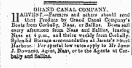
The story of the Corbally Canal goes back to 1811 and before, when the canal was first planned and built as a transport conduit for local businesses, including the Tuthill & Reeves Mill located two miles away in Athgarvan near Newbridge. Its industrial history revolved around the shipping of goods to Athgarvan, Kilcullen and Newbridge. Malt, flour and other raw materials were transported by cart along the Harbour Road to Corbally, where they were loaded onto barges in the Harbour, then carried along the Grand Canal to businesses in Dublin.

Published on August 29 1891 in the Kildare Observer
Canal Boats on the Corbally Canal
From the research carried out in 2021 by Claire Meehan and the writings of Ruth Delany, we can name two boats that were used on the Corbally Canal back in the late 1800s and early 1900s. They were Canal Boat No 75B and Canal Boat 12. Both of these boats would have been horse drawn and built of wood.
Byetrader No 75B
Ruth Delany wrote about 75B, see full article below. 75B was built in 1875, for Mr T B Reeves of Athgarvan, weighed in on March 311876. Sold to Grand Canal Company in 1886 and renumbered. Broken up in 1896.
GCC Company Boat No 12
Oct 14 1899 or thereabouts there is a record of Boat No 12, skippered by Andrew McCormack passing through the Locks on the Naas Canal. Boat No 12 was weighed on 17/03/1896 for the GCC, it was 59 ft 6 inches in length and 12 ft 8 inches in width, and did not have an engine. The Weighmaster was P Killeen.
From other accounts we know they used two horses with a full load when on the Corbally. ‘William Hall and John Dunne drove up to Corbally with the horses’. Later William Hall with a light load ‘yoked his horse’ in Naas after they had loaded empties.
2022 Update
Over the past eighteen months, the IWAI Corbally Group, consisting of local volunteers and members of IWAI Kildare, have continued to raise the profile of the Corbally Canal and Harbour, with in-depth research by Claire Meehan and others, into its connections with Athgarvan, Kilcullen, Naas, Newbridge and Sallins have been explored.
The output from this research into the history and infrastructure of the canal is a Video filmed by David Knox and narrated by local historian, Liam Kenny, with an accompanying Brochure produced by Eamon Sinnott. Kildare County Council has backed this initiative by providing a grant for the printing of the document. This publication visualises the known history and the future of the canal as a tourism and recreational amenity, for both local people and visitors. The launch of the brochure took place during Heritage Week 2022 and at the Naas Canal Festival 2022 in October.
There is a range of photographs in our Waterways’ Gallery section showing trips down the Corbally Canal in recent years, giving an indication of the potential of this amenity. More information: Naas Canal and Corbally Trip
2023 Update
In November 2023, it was announced that €45,000 has been allocated for a Feasibility Study ‘to assess the development potential for enhancing the Corbally Canal between Naas and Corbally Basin as a Greenway’. This initiative is part of the Corbally Canal and River Liffey Corridor Enhancement Scheme.
As part of the Outdoor Recreation Infrastructure Scheme (ORIS), Minister Humphreys announced the allocation of around €2.3 million to develop 50 new outdoor recreation projects throughout the country.
- Funding will support preparatory work required to bring large scale outdoor recreation projects to a shovel-ready stage
- Investment will ensure a strong pipeline of outdoor amenity projects right across the country in the coming years
Another Step Closer – thanks are due to all involved so far, in the research and promotion of the Corbally Canal as a future heritage, tourist and recreation waterway, available to local and visiting boaters, canoeists, cyclists, kayakers and walkers of all abilities and ages
2024 Updates
During the early part of 2024, the Harbour was drained, the silt island removed and the surrounding canal dredged. Kilcullen Diary published these photographs by Herbert Sheehan of Corbally Harbour during the work and after it was refilled.


Corbally Harbour 2024 © Herbert Sheehan
Subsequent to this work, the harbour was once again filled. Later in the year, Waterways Ireland carried out a clean up of the harbour. This news announcement shows Corbally Harbour in October 2024.
Canal Boat 75B by Ruth Delany
An interesting Memorandum of Agreement , dated 29th June 1875 was uncovered recently by Mr T.H.M. Reeves relating to the building of a canal boat for his grandfather T.B. Reeves of Athgarvan near Newbridge.
Agreement to build 75B
Thomas Heavey of Dorset Street, Dublin was the Shipwright and he undertook to build the boat for £260
…. “according to the specification prepared by Frederick Sharpe and signed by the parties hereinbefore mentioned and also to the lines and moulds which are to be given to the said Thomas Heavey, for his use during the time he shall be occupied in building said boat. Thomas Heavey hereby binds himself, his heirs, executors and assigns to furnish the said boat in a proper and workmanlike manner and to furnish and supply all workmanship and materials for same, as also all machinery plant and tools and the dock necessary for the building of the said boat at his own cost and charge, the entire both as regards materials and workmanship is to be executed in the best manner to the entire satisfaction of Me Frederick Sharpe or some other duly qualified person to be appointed by the said T.B Reeve Esq, should it become necessary to inspect and superintend same who shall have full power to reject and cause to be removed all defective or improper materials and imperfect workmanship. Payments are to be made to the said Thomas Heavey by instalments at the rate of 75% of the value of the works properly executed, and materials used in building of the boat. No instalment to be less than the sum of £50 fifty pounds sterling and the last or final instalment together with the remaining 25% is to be paid on the boat being completed and handed over to T.B. Reeves Esq. The said Thomas Heavey is hereby bound to have the said boat complete according to the specification within 14 weeks from the date of this agreement under a penalty of £2 per week …”
The agreement went on to protect T.B. Reeves if Heavey was unable to complete his contract by “his becoming bankrupt or in any other way incapacitated” and to ensure that the moulds should be returned to Mr Sharpe in good order.
75B – 1876 to 1896
A Grand Canal Company record book, shows that the boat was built in a Royal Canal Company Dock on the Broadstone Branch. She was weighed on the 31st March 1876 and numbered 75B. In 1886 she was sold to the Grand Canal Company and renumbered ??; it is probable that after that date the Athgarvan Company used the canal company as carriers. Ten years later in 1896, she was broken up for firewood.
The 75B would have operated from Corbally Harbour about 2 miles from Athgarvan Mills. T.B. Reeves had converted the mills into a maltings in the 1890s and Corbally Harbour was used to transport the malt to Guinness’s Brewery until the 1930s.
Traffic on the Grand Canal in 1870s
The 1870s were record years for traffic on the Grand Canal system and at that time a great deal of tonnage was carried by bye-traders and some by firms along the canal operating their own boats. In 1875 a total of 379,047 tons was carried and only 88,836 tons of this total was carried on the Grand Canal boats. The growth of the railways began to affect traffic and the Grand Canal Company took over an increasing portion of the trade.
KILDARE – COUNTY GEOLOGICAL SITE REPORT – 2005
NAME OF SITE Rathcore Spring
Other names used for site
TOWNLAND(S) Herbertstown
NEAREST TOWN Newbridge (An Droichead Nua)
SIX INCH MAP NUMBER 23
NATIONAL GRID REFERENCE 284360 213750 = E 844 138
1:50,000 O.S. SHEET NUMBER 55 1/2 inch Sheet No. 16
Outline Site Description
A spring that feeds the part of the Grand Canal known as the Naas and Corbally Branch.
Geological System/Age and Primary Rock Type
N/A
Main Geological or Geomorphological Interest
This spring is situated approximately 3.5km east of Newbridge town at the terminus of the Naas and Corbally Branch of the Grand Canal. The source of the spring cannot be seen due to high levels of vegetation but the constant flow of water from this spring can be heard from the banks of the canal.
Site Importance
A significant spring site worthy of CGS status in the context of Kildare.
Management/promotion issues
This land is owned by CIE. Access is through two large locked gates. This is an aesthetically pleasing site with ruined harbour buildings along the east bank of the canal. The area around the canal and spring appears to be reasonably managed with no dumping observed. This site is also the beginning of a canal walkway, which extends as far as Naas town to the northeast.

